Showing 192 items matching mining sites
-
 Eltham District Historical Society Inc
Folder, Victorian Goldfields Project: Historic gold mining sites in St Andrews mining division, 1999
... Victorian Goldfields Project: Historic gold mining sites in... sites in St Andrews mining division 35 page report with map ...Heritage site report and gazetteer by David Bannear, head consultant for archealogy for the Department of Natural Resources and Environment. Includes information on the Warrandyte Goldfield and the Caledonia Goldfield, Queenstown (now known as St Andrews), One Tree Hill, Kingston (now known as Panton Hill), Kangaroo Grounds, You You Hill, Kingstown, South Morang, Nillumbik, (now known as Diamond Creek), Steele's Creek, Yarrambet and Kinglake. Photocopy of map headed: Location of mines and reefs from Geological survey of Victoria, Yan Yean with the Diamond Creek prominant on the map. no date35 page report with map and print out of cover letter (email form) from donorcaledonian gold fields, caledonina gold field, david bannear, gold mining, harry gilham collection, queenstown, st andrews, warrandyte goldfield -
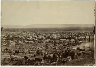
 Ballarat Heritage Services
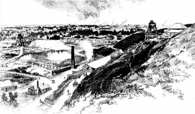
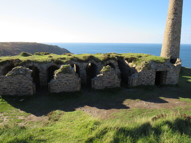
Photograph - Image - Black and White, Ballarat From Black Hill, 1888
... Image of a mining site on Black Hill, with the township..., 1888 Image of a mining site on Black Hill, with the township ...Image of a mining site on Black Hill, with the township of Ballarat in the background. black hill, mining, poppett head, black hill flat -
 Stawell Historical Society Inc
Map, Township of Stawell Photo Map, 1947
... Photograph of Stawell from Air Circa 1947. Shows mining... from Air Circa 1947. Shows mining sites and township mining ...Photograph of Stawell from Air Circa 1947. Shows mining sites and townshipmining, gold, map -
Tatura Irrigation & Wartime Camps Museum
Folder, Rushworth/Waranga, 2003
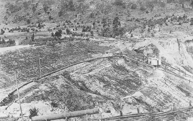
... mining sites.... rushworth-waranga mining sites goldfields tatura mining whroo ...Report on mines, including Balaclava. Extracts from Waranga News. Early happening, settlement life.Black cover with metal clips. Labels on spinerushworth-waranga, mining sites, goldfields, tatura, mining, whroo, documents, reports -
 El Dorado Museum Association Inc.
Photograph (item) - Digital Image
... of mining site showing long pipes used for sluicing and small tin... a black and white photograph of mining site showing long pipes ...Cocks Pioneer Electric Gold & Tin Mine Company was formed in 1899. The company's first power station, located at the eastern end of the valley began operating with its 340 Kilowatt steam-powered generator. By 1909, from 2,500,000 cubic yards worked, reported recovery was 17,284 ounces of gold and 224 tons of tin ore. By 1909, Cocks Pioneer’s power plant had become inadequate and uneconomical. The barge was floated downstream about a mile, but lost time caused the operations to cease. Following testing, a new mine was established by diverting Reid's Creek at a cost of £25 000. Settling dams were built, one of which held 1,935,900 cubic feet. Sold earth banks, built against a wall of stringy bark saplings constructed and laced with vertical props, were built. In 1914, the company was reformed as Cock’s Pioneer Gold and Tin Mines NL, another power station was constructed at the western end of the township, near the junction of Clear and Reid's Creeks. From 6,800,000 cubic yards of material processed, the returns were 64,397 ounces of gold and 855 ton of tin. Cocks Pioneer mine then moved the barge downs stream and continued sluicing. In 1929 Cocks Pioneer Electric Gold and Tin Mining Company ceased operations due to a drop in values. Cock’s Pioneer Gold and Tin Mines NL carried on large-scale hydraulic sluicing operations until 1941. gold, tin, mining, sluicing, gold mining, tin mining, cocks pioneer, el dorado, eldorado -
 Tatura Irrigation & Wartime Camps Museum
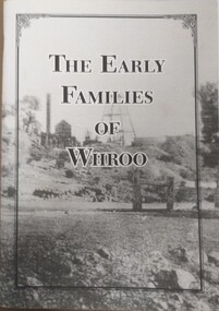
Booklet, The Early Families of Whroo
... mining site. 88 pages.... is a grey scale photograph of the Whroo mining site. 88 pages. title ...Tells a short story of the early families who settled at Whroo, a gold mining area, located near Rushworth. The town is no long in existence. Written by Doris KIngA5 size booklet with soft cardboard cover. Cover has a black frame in from the edge with the book title in that in black print. Cover is a grey scale photograph of the Whroo mining site. 88 pages.titlewhroo, families of whroo, doris king -
Stawell Historical Society Inc
Photograph, Stawell Gold Mine, Aerial Photomap of Stawell & Mining 1997, 1997
... Evaporation Dams Mining Site... Mining Geology Office 1997 Evaporation Dams Mining Site Mining ...Evaporation Dams Mining SiteLarge Laminated Aerial Photo Map showing Stawell and Mining activityMining Geology Office 1997mining -
 Stawell Historical Society Inc
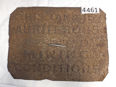
Memorabilia - Realia, 1850-1920's
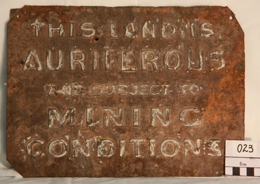
... in the vicinity of gold mining sites. From 1850'c to between the two... to be displayed in the vicinity of gold mining sites. From 1850'c ...Rusted Tin Sign – "THIS LAND IS AURIFEROUS AND SUBJECT TO MINING CONDITIONS" This sign was required to be displayed in the vicinity of gold mining sites. From 1850'c to between the two world wars. Found near Rhymney Hill Great Westernc1966stawell -
 Federation University Historical Collection
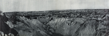
Photograph - Black and White, Ballarat from Black Hill - c 1880, c 1880
... Black Hill was a mining site and is now a suburb.... Circa 1880 Black Hill was a mining site and is now a suburb ...Black Hill was a mining site and is now a suburb of BallaratPanoramic, black and white photograph of Ballarat from Black Hill. Circa 1880ballarat, black hill, mining, railway, photograph, black and white -
 Greensborough Historical Society
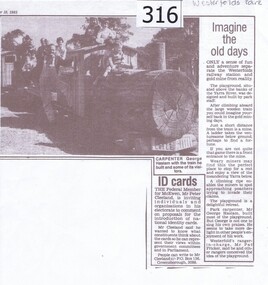
Newspaper clipping, Diamond Valley Leader, Imagine the old days, 10/09/1985
... News article relating the opening of a 'gold mining' site... relating the opening of a 'gold mining' site and wooden train ...News article relating the opening of a 'gold mining' site and wooden train at Westerfolds Park.Photocopy of article from Diamond Valley News 1985. Includes photograph of children on miniature train.westerfolds park, gold mine, parks, playgrounds, george haslam, yarra river -
Federation University Historical Collection
Book, Tourism at the University of Ballarat - 1996 AH&TE Conference: Historic Mining Site Management, 1996
... Conference: Historic Mining Site Management...Historic Mining Site... Conference: Historic Mining Site Management...: Historic Mining Site Management White soft covered folder. Tourism ...Tourism at the University of Ballarat - 1996 AH&TE Conference: Historic Mining Site ManagementWhite soft covered folder. mary hollick, public land in victoria, heritage legislation commonwealth, management issues, list of key mining heritage trails, preliminary market research, survey locations, university of ballarat, school of business, historic mining site, historic mining site management, tourism, mining heritage trails -
 Myrtleford and District Historical Society
Gold Mining Sign
... of gold mining sites. Myrtleford district was known to have had... to be displayed in the vicinity of gold mining sites. Myrtleford district ...This sign was required to be displayed in the vicinity of gold mining sites. Myrtleford district was known to have had 100 sites within a ten mile radius of the town; the sign was recovered by Charlie McFadyen, a local prospector and fossicker, of some 60 yearsThe sign relates to local gold mining activity, a key source of wealth and employment from 1854 to the late 19th century. Such signs continued to be in use during the period between World War 1 and 2,including the period of the Great Depression.Tin rectangular mining sign embossed with a warningInscription: "THIS LAND IS AURIFEROUS AND SUBJECT TO MINING CONDITIONS"auriferous mining -
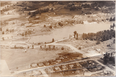
 The Beechworth Burke Museum
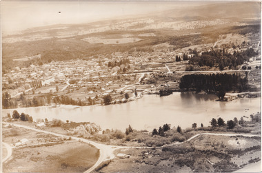
Photograph, Unknown
... as a mining site until the early 1900s, which brought Europeans... Mining company during the gold rush era and used as a mining site ...Aerial view of Lake Sambell, Beechworth with town views. Lake Sambell is a beautiful Victorian recreation lake and urban park with a unique history. It was created in the mid-1800s by the Rocky Mountain Mining company during the gold rush era and used as a mining site until the early 1900s, which brought Europeans into the area. It was turned into a reserve for residents in 1920 and is considered an icon of Beechworth as it represents the development of the community, human endeavour, and the spirit of the landscape.This photograph represents Lake Sambell with town views.Black and white reproduced rectangular photograph print on paper.Reverse: Stampbeechworth lake, lake sambell, aerial photo, construction, australian landscape, #beechworth, victoria -
 The Beechworth Burke Museum
Photograph, 1960
... rush era and used as a mining site until the early 1900s, which... as a mining site until the early 1900s, which brought Europeans ...Taken in 1960, depicted is an aerial view of Lake Sambell and the surrounding township. Lake Sambell is a beautiful Victorian recreation lake and urban park with a unique history. It was created in the mid-1800s by the Rocky Mountain Mining company during the gold rush era and used as a mining site until the early 1900s, which brought Europeans into the area. It was turned into a reserve for residents in 1920 and is considered an icon of Beechworth as it represents the development of the community, human endeavour, and the spirit of the landscape.This photograph represents what Lake Sambell looked like in 1960.Black and white reproduced rectangular photograph print on paper.lake sambell, #beechworth, beechworth 1960s, lake, victoria, australian landscape, mining, rocky mountain mining company -
 The Beechworth Burke Museum
Photograph, 1960
... during the gold rush era and used as a mining site until... as a mining site until the early 1900s, which brought Europeans ...Taken in 1960, depicted is the construction of Lake Sambell, looking west across the lake. Lake Sambell is a beautiful Victorian recreation lake and urban park with a unique history. It was created in the mid-1800s by the Rocky Mountain Mining company during the gold rush era and used as a mining site until the early 1900s, which brought Europeans into the area. It was turned into a reserve for residents in 1920 and is considered an icon of Beechworth as it represents the development of the community, human endeavour, and the spirit of the landscape.This photograph represents additional construction to Lake Sambell as a recreational reserve.Black and white reproduced rectangular photograph print on paper.beechworth lake, lake, lake sambell, construction, #beechworth, australian landscape, beechworth 1960s, victoria -
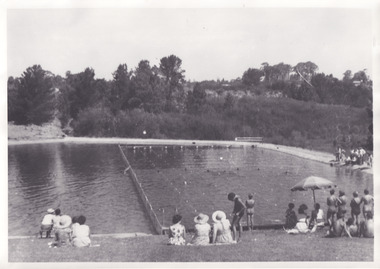 The Beechworth Burke Museum
Photograph, 1960s
... Mining company during the gold rush era and used as a mining site... as a mining site until the early 1900s, which brought Europeans ...Taken in the 1960s, depicted are approximately twenty-nine male and female spectators at a school swimming carnival on Lake Sambell near the caravan park. Lake Sambell is a beautiful Victorian recreation lake and urban park with a unique history. It was created in the mid-1800s by the Rocky Mountain Mining company during the gold rush era and used as a mining site until the early 1900s, which brought Europeans into the area. It was turned into a reserve for residents in 1920 and is considered an icon of Beechworth as it represents the development of the community, human endeavour, and the spirit of the landscape. This photograph represents the post-gold rush era use of Lake Sambell as a recreational reserve. Swimming carnivals were held at the lake and considered a social event for the Beechworth community.Black and white reproduced rectangular photograph print on paper.Reverse: Community/ Swimming pool 1960s/ near the caravan park/ Lakes?lake swimming pool, lake swimming, beechworth carnival processions, carnival, #beechworth, beechworth 1960s, victoria -
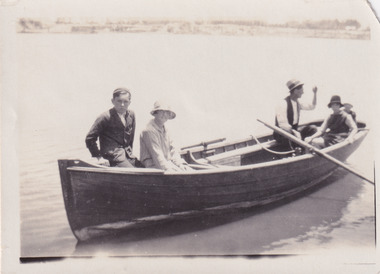 The Beechworth Burke Museum
Photograph, 1920
... Mining company during the gold rush era and used as a mining site... Mining company during the gold rush era and used as a mining site ...Taken in 1920, depicted are four people in a rowing boat on Lake Sambell, Beechworth. From left to right, it is believed that the names of the people are Eric Beard, Mrs Doris Beard, and S/L to Bert Beard. The last two figures are unknown. Lake Sambell is a beautiful Victorian recreation lake and urban park with a unique history. It was created in the mid-1800s by the Rocky Mountain Mining company during the gold rush era and used as a mining site until the early 1900s, which brought Europeans into the area. It was turned into a reserve for residents in 1920 and is considered an icon of Beechworth as it represents the development of the community, human endeavour, and the spirit of the landscape.This photograph represents the community's social use of the lake in 1920.Black and white rectangular photograph print on paper.Reverse: LAKE SAMBELL/ c 1920/ from LTOR/ 1 ERIC? - BERT'S SON/ 2 MRS DORIS BEARD/ 3 S/L TO BERT BEARD/ 4 #beechworth, lake sambell, lake sambell boating, beechworth lake, social, 1920, victoria -
 The Beechworth Burke Museum
Photograph
... of Beechworth that was possibly used as a sluicing mining site for gold... that was possibly used as a sluicing mining site for gold during ...This image shows an unknown location in the area of Beechworth that was possibly used as a sluicing mining site for gold during the Victorian Gold Rush. This era saw an influx of Chinese immigrants and Australian prospectors hoping to strike it rich on the fields. Many companies such as the Rocky Mountain Extended Gold Sluicing Company Ltd and the Cocks Pioneer Gold &Tin Sluicing Company also set up mines in the area. This site may be the location of one of these company's mines. The wooden logs are reminiscent of known sluicing operations in the era from that time. Sluicing involved the use of high-pressured hoses to clear away soil from earth that had been dug up by miners and was a popular method of excavation in the area, although it had severe impacts on the environment.The search for gold is ingrained into the history of Victoria and therefore, images like this one which portray an open cut sluicing site can reveal important information for society and technology for the date when the photograph was taken. This image is of important historical significance for its ability to convey information about sluicing and the methods used to find gold. It also shows a location where sluicing was undertook which provides insight into the impact of sluicing on the environment at a time when it was done.A colour rectangular photograph printed on glossy photographic paperReverse: 6855 /beechworth, gold rush, sluicing, mining -
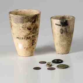 City of Greater Bendigo - Civic Collection
Equipment - Crucible, Bendigo Pottery
... level of pollution in a mining site. Stoneware crucibles... level of pollution in a mining site. Stoneware crucibles ...Assay is a process of metallurgy and chemical analysis used to determine proportions of precious metals in ores and other metallurgy substances such as silver or gold. The process helps identify pollutants present within a sample and can indicate a high level of pollution in a mining site. Stoneware crucibles are used in the fire assay process due to their ability to withstand high temperatures. Fire assay is a three step process where by samples from the mine are ground in a find powder and then mixed with dry powder chemicals. This mixture is heated in a crucible to extreme temperatures (crucible fusion) until all of the powers fuse into a glass like slag. Once this reaction is complete, the contents are poured into a mold and cooled. In step three (known as cupellation) the mixture is separated in a fire assay cupel and once this is complete the cupel with reveal a small bead of precious metals.Two stoneware vessels of differing dimensions (0287.1 & .2). Unglazed and porous, showing extensive signs of use. Stamped and marked on the outside. 0287.2 has a shaped pouring lip. Six smaller items, coins, buttons (0287.3,.4,.5,.6,.7,.8) were found with the crucibles but their relationship to the assay items is unknown.0287.1; Large crucible; Bendigo Pottery / E. 0287.2; Small crucible: Pottery / C Icity of greater bendigo commerce, city of greater bendigo mining, making a nation exhibition -
 The Beechworth Burke Museum
Geological specimen - Oil shale
... mining sites in Wolgan Valley such as Newnes. Newnes.... It could be linked to the abandoned oil shale mining sites ...This particular specimen is found in Wolgan Valley, New South Wales. It could be linked to the abandoned oil shale mining sites in Wolgan Valley such as Newnes. Newnes was an industrial complex operational in the early 20th century is now partly surrounded by Wollemi National Park. It produced motor spirit, kerosene, and gas oil. Newnes's Torbanite oil shale rock contained around 350 litres of oil shale per tonne. The Torbanite was mined by the Commonwealth Oil Corporation Ltd. Oil shale is a sedimentary rock and also a form of fossil fuel. It is often formed millions of years ago and usually contain fossilised remains of plants and/or animals. Oil shale is rich in kerogen that releases hydrocarbon when heated. These hydrocarbon can be used as an alternative petroleum or natural gas. The oil-shale rock was converted into oil by "destructive distillation"; the rock being heated until it broke down to form an oily vapour and an ash residue. Oil bearing shale is one of Australia's national assets. There are many oil companies established in Australia. It reflects Australia's rich natural resources as well as connection to the Australia's engineering and oil industry. The booming oil shale extraction businesses can be traced as far back as 1920s. This specimen is part of a larger collection of geological and mineral specimens collected from around Australia (and some parts of the world) and donated to the Burke Museum between 1868-1880. A large percentage of these specimens were collected in Victoria as part of the Geological Survey of Victoria that begun in 1852 (in response to the Gold Rush) to study and map the geology of Victoria. Collecting geological specimens was an important part of mapping and understanding the scientific makeup of the earth. Many of these specimens were sent to research and collecting organisations across Australia, including the Burke Museum, to educate and encourage further study.Piece of dark gray oil bearing shale with shades of light brown and fossilised leavesExisting label: OIL BEARING SHALE with / FOSSILISED LEAVES / Locality: Wongan Valley, NSW / Donor: Miss M. Cambell geological specimen, geology, geology collection, burke museum, beechworth, oil shale, shale, fossil fuels, alfred selwyn, wolgen valley, 1868 geological survey of victoria, rocks, sedimentary rocks, newnes, torbanite, commonwealth oil corporation ltd -
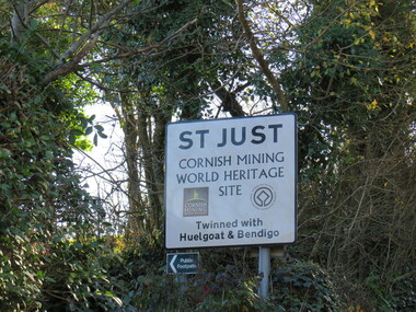 Ballarat Heritage Services
Photograph - Colour, Sign, St Just, Cornwall
... that St Just, Cornwall is a Cornish Mining World Heritage Site... Just, Cornwall is a Cornish Mining World Heritage Site twinned ...Many miners came from the St Just are in Cornwall to Ballarat, Victoria, Australia for the gold rushes. This sign reads that St Just, Cornwall is a Cornish Mining World Heritage Site twinned with Huelgoat and Bendigo.ellis, st just, bendigo, miners -
 Stawell Historical Society Inc
Photograph, View of Stawell from Big Hill April 1874 centered on north end of Main Street -- 2 Photos
... Hill with mining in foreground. 1874 Site of fire in Main..., Matherson Cross Reef Hotel. mining panorama Streetscape Black ...From left Shire Hall Pleasant Creek in distance, Mathers & Franklin, Stawell Coach Factory, Coffee Palace, Christ Church of England Church Hill, Mechanics Institute, Temperance Hotel, Matherson Cross Reef Hotel.Black and White Holtermann photograph of Stawell from Big Hill with mining in foreground. 1874 Site of fire in Main and Street Patrick Street 22 April 1874 visible in centre of photograph.mining, panorama, streetscape -
 Ballarat Heritage Services
Photograph - Colour, Dorothy Wickham, St Just, Cronwall, World Heritage Site
... and photographers. World-famous for their mineralogy, the mining sites here... and photographers. World-famous for their mineralogy, the mining sites here ...A stone’s throw from Land’s End, this is the most westerly Area of the Site. St Just is characterised by big skies, jagged rocks, stark moorland, and iconic clifftop engine houses perched above the Atlantic in some incredible locations. No wonder this dramatic setting has inspired generations of artists, writers and photographers. World-famous for their mineralogy, the mining sites here are extremely well preserved – as is the sense of community amongst the people whose lives they once dominated. This Area’s unique geography and mineralogy meant that undersea mining was more concentrated here than anywhere else in the world in the 18th and 19th centuries. The oldest surviving Cornish beam engine (constructed in 1840) remains in its original engine house at Levant, restored and still working under steam. Geevor, one of the last mines to close in Cornwall (1990), was saved from demolition and is now the largest metalliferous mine site open to the public in the UK. The historic mining town of St Just is home to characteristic rows of granite mine workers’ cottages, public squares, shops, cafés, art galleries and, just off Bank Square, a medieval grassed amphitheatre – the Plen an Gwary or ‘playing place’.st just, world heritage, ellis, penrose, cornwall, mining, mines -
 Ballarat Heritage Services
Photograph - Colour, Dorothy Wickham, St Just, Cornwall, World Heritage Site
... and photographers. World-famous for their mineralogy, the mining sites here... and photographers. World-famous for their mineralogy, the mining sites here ...A stone’s throw from Land’s End, this is the most westerly Area of the Site. St Just is characterised by big skies, jagged rocks, stark moorland, and iconic clifftop engine houses perched above the Atlantic in some incredible locations. No wonder this dramatic setting has inspired generations of artists, writers and photographers. World-famous for their mineralogy, the mining sites here are extremely well preserved – as is the sense of community amongst the people whose lives they once dominated. This Area’s unique geography and mineralogy meant that undersea mining was more concentrated here than anywhere else in the world in the 18th and 19th centuries. The oldest surviving Cornish beam engine (constructed in 1840) remains in its original engine house at Levant, restored and still working under steam. Geevor, one of the last mines to close in Cornwall (1990), was saved from demolition and is now the largest metalliferous mine site open to the public in the UK. The historic mining town of St Just is home to characteristic rows of granite mine workers’ cottages, public squares, shops, cafés, art galleries and, just off Bank Square, a medieval grassed amphitheatre – the Plen an Gwary or ‘playing place’.st just, world heritage,, ellis,, penrose, cornwall, mining, mines -
 Ballarat Heritage Services
Photograph - Colour, Dorothy Wickham, St Just, Cornwall, World Heritage Site
... and photographers. World-famous for their mineralogy, the mining sites here... and photographers. World-famous for their mineralogy, the mining sites here ...A stone’s throw from Land’s End, this is the most westerly Area of the Site. St Just is characterised by big skies, jagged rocks, stark moorland, and iconic clifftop engine houses perched above the Atlantic in some incredible locations. No wonder this dramatic setting has inspired generations of artists, writers and photographers. World-famous for their mineralogy, the mining sites here are extremely well preserved – as is the sense of community amongst the people whose lives they once dominated. This Area’s unique geography and mineralogy meant that undersea mining was more concentrated here than anywhere else in the world in the 18th and 19th centuries. The oldest surviving Cornish beam engine (constructed in 1840) remains in its original engine house at Levant, restored and still working under steam. Geevor, one of the last mines to close in Cornwall (1990), was saved from demolition and is now the largest metalliferous mine site open to the public in the UK. The historic mining town of St Just is home to characteristic rows of granite mine workers’ cottages, public squares, shops, cafés, art galleries and, just off Bank Square, a medieval grassed amphitheatre – the Plen an Gwary or ‘playing place’.st just, world heritage, ellis, penrose, cornwall, mining, mines -
 Ballarat Heritage Services
Photograph - Colour, Dorothy Wickham, St Just, Cronwall, World Heritage Site
... and photographers. World-famous for their mineralogy, the mining sites here... and photographers. World-famous for their mineralogy, the mining sites here ...A stone’s throw from Land’s End, this is the most westerly Area of the Site. St Just is characterised by big skies, jagged rocks, stark moorland, and iconic clifftop engine houses perched above the Atlantic in some incredible locations. No wonder this dramatic setting has inspired generations of artists, writers and photographers. World-famous for their mineralogy, the mining sites here are extremely well preserved – as is the sense of community amongst the people whose lives they once dominated. This Area’s unique geography and mineralogy meant that undersea mining was more concentrated here than anywhere else in the world in the 18th and 19th centuries. The oldest surviving Cornish beam engine (constructed in 1840) remains in its original engine house at Levant, restored and still working under steam. Geevor, one of the last mines to close in Cornwall (1990), was saved from demolition and is now the largest metalliferous mine site open to the public in the UK. The historic mining town of St Just is home to characteristic rows of granite mine workers’ cottages, public squares, shops, cafés, art galleries and, just off Bank Square, a medieval grassed amphitheatre – the Plen an Gwary or ‘playing place’.st just, world heritage, ellis, penrose, cornwall, mining, mines -
 Ballarat Heritage Services
Photograph - Colour, Dorothy Wickham, St Just, Cornwall, World Heritage Site
... and photographers. World-famous for their mineralogy, the mining sites here... and photographers. World-famous for their mineralogy, the mining sites here ...A stone’s throw from Land’s End, this is the most westerly Area of the Site. St Just is characterised by big skies, jagged rocks, stark moorland, and iconic clifftop engine houses perched above the Atlantic in some incredible locations. No wonder this dramatic setting has inspired generations of artists, writers and photographers. World-famous for their mineralogy, the mining sites here are extremely well preserved – as is the sense of community amongst the people whose lives they once dominated. This Area’s unique geography and mineralogy meant that undersea mining was more concentrated here than anywhere else in the world in the 18th and 19th centuries. The oldest surviving Cornish beam engine (constructed in 1840) remains in its original engine house at Levant, restored and still working under steam. Geevor, one of the last mines to close in Cornwall (1990), was saved from demolition and is now the largest metalliferous mine site open to the public in the UK. The historic mining town of St Just is home to characteristic rows of granite mine workers’ cottages, public squares, shops, cafés, art galleries and, just off Bank Square, a medieval grassed amphitheatre – the Plen an Gwary or ‘playing place’.st just, world heritage, ellis, penrose, cornwall, mining, mines -
 El Dorado Museum Association Inc.
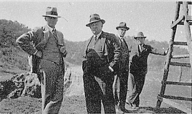
Photograph - Digital Image
... Mining Dredge building site. Cropped image from scanned sheet... near the Cock’s Eldorado Gold and Tin Mining Dredge building ...Four men touring near the Cock’s Eldorado Gold and Tin Mining Dredge building site. Cropped image from scanned sheet of negative proofs. Cock's El Dorado Gold & Tin Mining Dredge operated between 1936 and 1954. At the time of its construction, the dredge was the largest in the Commonwealth, producing 2,198 kg of gold.mines, mining, gold, gold mining, men, hats, cock's el dorado dredge, dredge, el dorado, eldorado -
 The Beechworth Burke Museum
Photograph
... was involved in promoting the transformation of the mining site... was involved in promoting the transformation of the mining site ...The photograph depicts two young men standing atop a prominent outcrop at Lake Sambell, with buildings visible on the further shore. The present day park and reserve occupies the site of the former Rocky Mountain Mining Company, an open-cut sluice mine that began operations in the mid-Nineteenth Century and operated until the early 1900s, through the peak of Victoria’s Gold Rush. It was converted into a park and leisure area in the 1920s. Lake Sambell was formally opened to the public on Friday 5th October 1928 and was opened by the Victorian Government’s Minister of Lands, Mr Bailey, as part of initiatives to boost the economies and development of country towns. The lake was named after Mr L.H. Sambell, a shire engineer and secretary of the Forward Beechworth Committee who was involved in promoting the transformation of the mining site and promoting plantation forestry and tourism as alternative industries. £300 to begin the process was provided by Mr J. McConvill, a former resident of Beechworth, who is remembered in a street name adjacent to the lake. An article in the Ovens and Murray Advertiser on Saturday, 5th May, 1917, gives some insight into issues in the Rocky Mountain Mining Company’s final years. The writer details the 1917 annual meeting of the Rocky Mountain Mining Company, stating that locals present appeared ‘well pleased this important local industry is in such a prosperous condition and that future prospects are so encouraging’. The author describes plans to give workers a bonus as evidence of profit-sharing that would ‘bridge the gulf between capital and labour’. The article concludes, however, with the statement that ‘there is a little arithmetical puzzle in the report in connection with the dredging operations I have been unable to solve.' The photograph is significant as it contributes to knowledge about how Beechworth reinvented itself after the Gold rush period, and more broadly how country towns repurpose and redevelop infrastructure and facilities to meet the present needs of their population. Sepia rectangular photograph printed on matte photographic paper. Obverse: nil. Reverse: 3471 / Velox (paper mark)beechworth, beechworth lake, lake sambell, l.h. sambell, mcconvill, rocky mountain mining company, rocky mountain mining co, minister of lands, forward beechworth committee, wallace park-lake sambell development scheme, wallace park lake sambell development scheme, lake, sambell, j. mcconvill, recreation, reserve, park, transformation, repurposed, redeveloped